|
Table of Contents
Maps
Next
Chapter
CHAPTER IX SUNSET RAMPART AND THE SOUTHWESTERN QUADRANT TRIPYRAMID, as its name indicates, is a triple-peaked mountain, all three of whose peaks seem to rise from a nearly horizontal ridge. Tripyramid towers high above the surrounding peaks except one―Passaconaway. Its three peaks taper up from the ridge into sharply pointed cones or pyramids. From our valley they remind one of the steam-domes and sand-boxes on the boiler of a huge modern locomotive. Just below the crest of this ridge, a monster bear, chased for three days by Jack Allen and his son, met his fate. Because of its sharp peaks this mountain was formerly known by the people near its western slopes as Waterville Haystack.1 Then, too, from its awful grandeur, it long bore the name of Passaconaway.2 Later this royal name was transferred to another gigantic pile of rock of nearly the same height, Tripyramid's altitude being 4,121 feet, while Passaconaway is 4,116 feet.3 Tripyramid is wooded to the summit and the ground is strewn with "tangled and bristling evergreens," so that if any view is to be obtained one must go to the ledges on the southern side. Here a wonderful view of the lake-country may be enjoyed.4 The west side has two mammoth land-slides. In Waterville the word "Tripyramid" is almost synonymous with that of "land-slide." "The Great Slide on Tripyramid is considered by many visitors the most remarkable object among the curiosities of Waterville. It commences about two miles from Greeley's, at the ancient clearing known as Becky town, and is reached by taking the path to the Cascades and diverging to the left at the forks (about one and a quarter miles from the house). Becky town is 280 feet above Greeley's, and from this point the Slide may be ascended for two miles, gaining a farther altitude of 1,015 feet. This section of the devastated valley is followed by a small stream, and the fringes are encumbered with the high-piled remnants of the ruined forests. It is here over 1,000 feet wide, where the debris spread over the meadows, and it decreases in the ascent to 125-300 feet wide. The upper half-mile narrows gradually from 640 to 30 feet, and has an angle of about 34°. "At two miles above the foot, the Slide turns at right angles with the brook, coming down directly, off the sharp slope of Tripyramid, very broad, heaped with bare white rocks and their disintegrated fragments, and breaking down to the bed-rock in frequent places. This section is about a half mile long, and rises 1,100 feet, giving for the whole slide a length of two and a half miles, and an altitude from base to top, of 2,115 feet. The brook section is comparatively easy of ascent, but the upper half mile is so extremely steep as to enforce slow advance on the part of the climber, whose footing, moreover, is often very insecure. Beautiful views of Lake Winnepesaukee and the mountains to the south and west are afforded in retrospect. The great natural convulsion which caused this catastrophe took place during the remarkable rains of the year 1869, but was unattended with any loss of life or property. The Slide contains many points of interest to geologists and other scientific men. The rocks on the lower half are labradorite and ossipyte, and the white boulders above are granitic."5 The second slide is on an even larger scale. This slide is not far from the first. It seems to have laid open almost the entire southwestern side of the mountain. The downpour of August 13, 1885, was the cause of this slide. A Waterville man has given us the following interesting account: "On Saturday, the fifteenth, a small party, including Mr. Butler, started to find the new slide and examine it. At 'Becky town' we found that most of the old clearing had disappeared. The brook-bed was a waste of sand and rock nearly two hundred feet wide. A few rods higher up, the width of the havoc and the amount of the debris was doubled. Boulders and great stones, scattered or piled in confused masses; high banks of mud, now being cut and channeled by many streams; piles of logs and stumps; trees stripped of limbs and bark, cruelly bruised and hammered, broken asunder like matches or twisted like withes; young trees bent over and their tops buried in mud and sand; cords of driftwood in the corners, often ground to fragments, finger size―this was the destruction before us. And this, with narrower limits and slight variations, was the scene of the next two miles. . . . Boulders piled higher than one's head extended in long lines parallel with the current, while the hard-pan of the bed rock was plowed down five, ten, and even twenty feet to the underlying granite. . . . Spruces five feet in diameter were broken like pipe stems. Birches almost as large were twisted off, leaving their ends like basket-stuff. Great gnarly stumps partially torn asunder were frequently seen, but never a limb nor a branch; they had been broken and carried away, or ground into undistinguishable fragments. We saw cracks and crevices in the ledges wedged tightly with log fragments; stones up to four inches in diameter driven their whole size into the sides of green tree trunks; boulders bruised and scarred as though hammered by sledges of iron. . . . As one nears the foot of the mountain, these, masses of slide salad become hills of twenty, thirty and forty feet in height. . . . This new slide is at the east of and joins at the base of the 1869 slide. . . . The two have made the fair mountain a desert of rock. A narrow strip of forest separates the two slides from near the top to two-fifths of the way down. The slide of 1869 is thirty feet wide at its apex; that of 1885 is over an hundred feet. The widest part of the old equals that of the new, but the new maintains a twenty-five per cent greater average width. The slide of 1869 has one apex, that of 1885 has three."6 While this new slide was roaring down, the old one, not to be outdone, started afresh, ten rods above its ancient apex, and, rumbling over the scarred bed, contributed its mite to the debris in the valley.7 Tripyramid may be ascended by a trail from our valley, although it is a long, hard day's work. The ascent usually is made, however, from Waterville, by trails up the slides, a climb of 6½ miles.8 It has even been ascended by snow-shoe parties from its western side.9
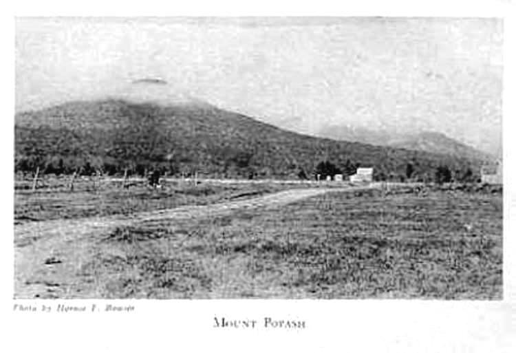
Between our valley and Tripyramid the bald head of Potash shines. Although in figures on the map this little hill looks negligible, yet its steepness, shape, and bare ledges give it an imposing distinctiveness. Potash is conspicuous when seen from a distance because of its coarse white granite peak; this granite, the same as is found on the expansive ledges of Tremont and Green's Cliff, is known as "Conway Granite."10 A very fine view of this stone may be had on the northwestern slope of Potash at Sabbaday Falls. Potash is said by Osgood to be only a mile and a half from the Passaconaway House site,11 but, from repeated experiences, I can testify that these are "mountain miles." Were I to guess the distance, I should call the climb a good stiff 2½ miles. Potash, so named because of its resemblance to an inverted potash kettle, may be ascended by a path (now uncertain). From the first lookout, a lower spur of the mountain, a well defined path runs to the great ledges. This tiny path passes through gloomy stretches of woods, sometimes running over moss-covered ledges, then plunging again into the silent depths. I think this little path is one of the most beautiful patches of scenery in the Albany Intervale. The first lookout is a promontory some distance east of the dome itself. Like the summit, it presents a distinct, though blunted cone, and is separated from the summit by a slight ravine. Fine views are enjoyed from this lookout. Pressing on to the summit we find that the top of Potash is broad and flat, necessitating a walk from side to side in order to get views in all directions. Potash's altitude is about 3,000 feet. There is one most interesting and unique natural phenomenon which is known as the "Balanced Boulder." It is a smoothly rounded rock about five feet high and ten feet long. This stone may be rocked by the hand. In the summer of 1915, while rocking it back and forth some boys pushed it too hard and it rocked too far, sticking fast. After much coaxing with wooden levers we finally prevailed upon it to return to its original pivot so that now it is in working order again. This boulder may be found lying a trifle below the southeastern side of the summit. From this little mountain the view is superb. To the east, our valley, with its few tiny houses, ribbon-like road, and the silver thread of river unroll at our feet. Bear, Moat and Chocorua form an ideal background. Southward loom the bristling Hedgehog, massive Passaconaway and Whiteface. From nowhere else can so good a view of Passaconaway's slide be obtained as from the top of Potash. The slide squarely faces us and seems very near. On the west and to the north stretch miles and miles of unbroken forest. Scores of mountains are in sight. In these directions not a sign of human habitation is to be seen. The poet's longing "for a lodge in some vast wilderness"12 could be satisfied here. At certain times in the year, namely, in the blueberry season, a lunch need not be carried; but a weapon, for defense against bears, is not amiss; Potash is a good "blueberry mountain" and hence popular among the ursine inhabitants of "cloudland." Potash is one of the best "little" climbs to be had here, and one ought not to leave the Albany Intervale without scaling its broad ledges. From the Albany Intervale, Mt. Whiteface appears as a wooded dome rising above the lofty ridge which extends from Passaconaway to Tripyramid. But from the country south of the Sandwich Range the appearance of Whiteface is entirely different. The wooded dome becomes a huge face of granite cliffs. Because of this aspect from the lake country it was named Whiteface. In October, 1820, a landslide laid bare its southern face,13 forever literally making the mountain a Whiteface. Whiteface may be ascended by path from the south side, from Passaconaway, from Tripyramid or from Sandwich Dome; the plateau of Flat Mt. connects Whiteface with the last, says Osgood. From the southern side, at McCrille's farm in the northeastern part of Sandwich Township, the path follows up the great ravine for three miles. The remaining mile is a hard pull over long stretches of ledge and stones. Usually within three to four hours from the time of entering the woods the summit is reached.14 The U. S. Coast Survey erected a signal-pole on the summit and from here a comprehensive view of the lake-country may be enjoyed. If one desires he may obtain fine views from the northwestern lookout. A well worn path leads from the summit a little to the northeast, where there is a deliciously cool spring.15 Few but the hardy climb Whiteface from our Albany side, although it is frequently ascended from the south. Its gigantic granite face towers 4,057 feet above sea level,16 or over 150 feet lower than Passaconaway and Tripyramid, its two nearest and loftiest neighbors. There is an A. M. C. register on Whiteface. Before leaving Whiteface let us recall Lucy Larcom's lines:
And another has been moved to pen the following:
All but one of the southern peaks are treated in separate chapters as they bear Indian names, namely, Passaconaway, Wonalancet, Paugus and Chocorua. The remaining one is the bristling, hump-backed hill named Hedgehog. This little mountain presents an entirely different appearance from points not far distant from each other. From Mrs. Colbath's, a mile and a quarter down the road from the hotel site, Hedgehog would hardly be recognized as the Hedgehog visible from our cottage; while from Square Ledge, its scrawny cliffs present an appearance both wild and terrible. From one place in the road this mountain, with one end high in the air and the other lost in obscurity, resembles a sinking ship with bow high in the air, while the stem is submerged beneath, the waves. Especially when its leaves have turned, in the autumn, Hedgehog appears beautiful and even artistically shaped. Its two great ledges―Allen's Ledge on the north and the huge glass-like roof on Little Hedgehog to the southeast―shine like silver epaulets above and between these shoulders it lifts a massive head. (This is the only hedgehog on record as wearing epaulets.) Such is Hedgehog as seen from our part of the valley. It is about 2,600 feet high. The lumber butchers unmercifully have slashed the poor porcupine, stripping it of many of its quills. Yet its sides are still very thorny, trash wood and debris being strewn every which way. Perhaps because of this, or from the fact that very similar is its view to that from Potash (Hedgehog's horizon, however, being much more restricted) this mountain is seldom, if ever, ascended―to the summit―by visitors. To all who come into the Albany Intervale, however, even to people past the mountain-climbing age, I would suggest that they go up to Allen's Ledge. This vantage-point affords a remarkable view―very similar to that seen from the higher lookouts―of all but the lake-country. Allen's Ledge gives you more for your money than any other climb. You see the Passaconaway Intervale, Chocorua, the Moats and other eastern peaks, and the Presidential Range, the Nancy, Carrigain and other ranges. On clear days we have been able to trace the slow upward crawl of the unique Mount Washington engine by the puffs of smoke it emits while "chugging" upward. By the aid of the glass, the buildings on Washington are made out. Vast stretches of unbroken wilderness unroll before our eyes, and, by the light and dark growths, the track of fire, hurricane and ax can be traced from the Carrigain Range to Moat, Paugus, Chocorua and Bald. Time and again while reclining upon these sun-kissed ledges we have seen eagles majestically wheeling overhead. Here, on one occasion, I lay awaiting the onslaught of a howling wild-cat which didn't attack, and here the bears come for their blueberry pies. All this for only a half mile's tramp after entering the woods! Allen's Ledge received its name when an inquirer tasked Jack Allen what those rocks on Hedgehog were called. The reply was prompt and unhesitating: "Them are called Allen's Ledge!" So from that day they have been Allen's Ledge, an enduring monument to human modesty and veracity. Once an aged guest who was visiting us suggested that we spend our noon hour on Passaconaway's summit―this being her first visit to mountain land, she was a poor judge of mountain distances. At length we prevailed upon her to attempt Allen's Ledge first. She found even this little scramble sufficiently strenuous to satisfy her ambition to "do" a mountain. Being very rheumatic, she discovered that the descent was even more difficult than the upward climb―it being much harder on the knees to descend than to ascend. But the remarkably fine view from the ledge amply compensates one for the slight exertion, even if one belongs in the stiff-kneed class. Every American mountain-lover should plan to visit these "Highlands of New England" before or after seeking those abroad. Many widely traveled tourists claim that our own Crystal Hills are as attractive and interesting as those "across the pond." In a letter which Henry Ware, Jr., wrote home in August, 1831, he says: "Nine miles to Sandwich to breakfast, by a route among the hills, very like some pretty spots in Switzerland."19 The Albany Intervale has often been likened to the valley of the Rhone. The more one studies, climbs, and conquers these ozone-bathed heights, the more beautiful, protecting, and romantic they become. Love of this historic wilderness grows upon one; and when one once has drunk " in the glory and strength of the mountains, be he native highlander or city-born, if "cabin'd, cribb'd, confined"20 within the suffocating brick walls of "civilization," he pines for the soul-thrilling freedom and exhilarating out-of-doorness of wind-swept, cloud-washed, sun-kissed sky-land.
_____________ 1. Chas. Fay in Appalachia, vol. I, 23. |