|
Table of Contents
Next
Chapter
CHAPTER VIII THE NORTHERN SKY-LINE Looking northward from the upper end of the Albany Intervale, a charming picture is seen. In the foreground lie the level meadows, terminating at the sandy beach of the Swift River. Tall trees artistically fringe the farther bank of the winding stream. Then the deep forest begins for a short space stretching over level ground and then rising until, at length, the silver-threaded crest of Birch Ridge is gained. As a fitting background to this restful foreground is an imposing semicircle of mountains reaching from Bear to Hitchcock. These peaks, some light green, others covered with dark growth and still others a deep purple or blue, here and there displaying a ledge or rocky summit, form what is considered by many one of the most thoroughly satisfying and typical mountain sky-lines in New Hampshire.
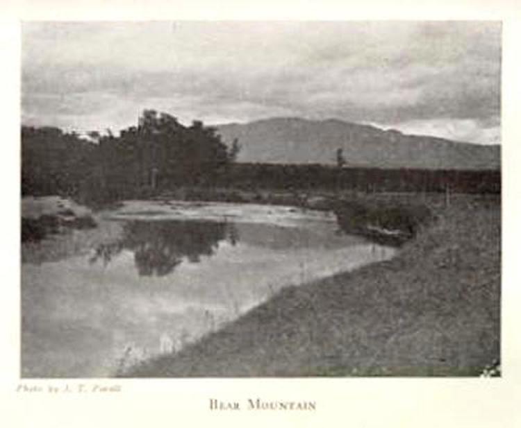
In the eastern corner, over whose southern shoulders the first glow of dawn appears, lies Bear Mountain, between the valleys of the Saco and the Swift.1 Appropriately indeed was this wilderness monster named. The dark furry back, well rounded, and humpy near the shoulders, the little ridge of fur rising on the wrinkled neck, and the bent head smothered in its massive paws, easily shapes itself into a great bear in repose. Of course all depends upon the viewpoint. From the town road at the base of Bear, the mountain appears precipitous and angular; while from our end of the intervale, southwesterly from Bear, not a sharp angle is seen. Its surface is all smooth knobs. Years ago Bear was clothed in a coat of dark spruces. The lumbermen have sadly mutilated its western slopes, leaving huge, ghastly slashes from their merciless shears. Time is gradually restoring the original beauty, however. Although of insignificant altitude, Bear is imposing. It is rarely visited, however.2 This is because, first, there is no path to the top. After leaving a logging road, which terminates well up on its side, one must strike through a tangle to reach the top of the ridge. An almost impenetrable growth has shot up among the tumbledown and the very summit is so barricaded with prostrate logs, underbrush and stones that the intrusion of a climber seems to be resented.3 The second and weightier reason is that, as the top is heavily wooded, one must seek fragmentary views from distant lookouts. But even from these lookouts only an ordinary view may be had. Of Chocorua, Moat, the surrounding peaks and our valley the view is good, but of Washington and its neighbors, only moderate.4 Between Bear and Bartlett Haystack―northwest of the former―lies the Bear Mountain Notch, through which many trampers pass. This affords the shortest cut from the Albany Intervale to the Presidential region. Years ago the Bartlett Land and Lumber Company built a railroad through the notch, but this long ago rotted away. A bright spot on the "Notch Trail," in the very heart of lonely solitude, was a cozy little cabin formerly owned by Charlie Brewster, who lived there alone on the side of Bear for a number of years.5 High above and in plain sight from the road, and perhaps accessible from it, a flat-topped ridge extends from Bear to Moat; this is known as Table Mountain.6 This mountain is not visible from our "Great Intervale," however. Table is only 2,663 feet in altitude, while Bear is 3,230 feet.7 Bartlett Haystack, also known as Silver Spring or Revelation,8 lies to the northwest of Bear. From our valley the mountain resembles a saddle more than a haystack, there being a deep depression between two wooded cones. For a low mountain Bartlett Haystack is imposing, because of its sharpness. It is only 2,995 feet in altitude.9 Remarkable views of the Albany and Bartlett valleys, and good views of the surrounding country and the Presidential mountains may be enjoyed. From either Cobb's Ford, in Bartlett, or by the "Notch Trail," the ascent usually is made. The latter, although shorter, is much more difficult, there being no definite trail, and no party should attempt to climb by this route without either an experienced woodsman or one well acquainted with the local terrain. The view fully repays one for his toil.10 The third mountain in our northern sky-line, as our eyes travel from east to west, is Tremont, whose peak several years ago was swept by fire,11 but which nature is slowly re-clothing. Because of a ridge uniting Tremont with its more northeasterly neighbor, of which we have spoken in the preceding paragraph, these two mountains are known jointly as the Bartlett Hay-stacks.12 Tremont's bare granite summit is somewhat rounded at the top, and from Chocorua's heights resembles a sharp cone, gorgeously glittering when snow-covered in winter. From "Shackford's" it appears as a huge, white-capped wave. This mountain is a cluster of lowly peaks which at length condense into one knobby ridge.13 A slide on its southwestern slope extends from near the summit to the edge of Sawyer's Pond, and may be seen from many of the neighboring lookouts. One can get a glimpse of this slide even from Sabbaday Falls. Many claim that the semicircular hill-top south of Tremont is only a spur of Tremont, while others assert that it should be classed as a separate mountain. This is Owl Cliff. Its massive face strikingly reminds one of an owl: There are the huge, hollowed-out eyes, separated by a prominent curved beak, and the trees at its base form the feathery neck and shoulders. Especially at approaching dusk or on bright moonlight evenings is this resemblance the more remarkable. Then the beak shines, and the huge dark eyes seem alive and dancing with their savage fire. The most frequent visitors to these peaks are deer and bear. For several summers a pair of eagles apparently had their home on or near the ledges of Owl Cliff. At the foot of the precipices, the deer make their yard during the winter, and you may see many trees with the bark stripped off by deer to the height of six or seven feet. From our valley the ascent of either Tremont or Owl Cliff should not be attempted without some knowledge of the lay of the land, for one easily loses his way.14 An A. M. C. register may be found on Tremont. From the summit are enjoyed fine views of the Presidential and surrounding ranges, the Swift and Saco valleys, and the Carrigain Notch.15 The hope has been expressed that, by running a path from Upper Bartlett, Tremont may be opened up to a larger number of trampers.16 From the Albany side the route would be too long and arduous. Tremont is 3,365 feet in altitude, lifting its peak 415 feet above Owl Cliff, which is 2,950 feet high.17 To the north of our cottage, in the blue distance, lies a truly Alpine scene. Between Tremont and the Carrigain Notch are three sharp peaks. This range is known as the Nancy Range, and comprises Lowell, Anderson, Nancy and Bemis. Mount Bemis, however, is not visible from our valley. These mountains are heavily wooded and are separated at their bases by tiny lakes.18 Taking the Nancy Range from west to east, let us begin with Lowell, the sharpest of the group. Lowell is a real mountain and, among the many peaks visible from our cottage, it is one of the few which remind us of the sharp mountains of Switzerland. Lowell's western side drops off with terrible steepness, forming the eastern wall of the Carrigain Notch. Its sheer cliffs have, been left bare by huge slides. Lowell was formerly Brickhouse Mt., but in 1868 its name was changed to Lowell, in honor of a Portland gentleman who was an enthusiastic mountain explorer.19 Mount Anderson, five feet lower than Lowell, is east of the latter, but because of its massive shoulder and less angular outlines, it presents a far less imposing appearance and seems like a much lower mountain. Mr. Anderson, for whom this peak was named, was the chief engineer of the Portland and Ogdensburg Railroad.20 For the benefit of those who wish to climb these mountains, the following directions will be found helpful―Mts. Lowell and Anderson can best be ascended by leaving the Carrigain Notch trail just north of the Notch and following up a depression between them in an easterly direction until the Livermore-Lincoln town boundary, a blazed line, is struck. Turning south on this line, the summit of Mt. Lowell may be reached in about a mile of very steep climbing, while north about the same distance and same steepness is Mt. Anderson. An outcropping ledge on the west side of Anderson, near the line, gives a wonderfully fine view of Carrigain, Carrigain Notch, and the Pemigewasset Wilderness. An A. M. C. register is at this point. Passing over the summit, the boundary may be followed down into the valley between Anderson and Nancy, the line passing between Norcross Pond and Nancy Pond, though not within sight of either. The line may be followed up the south slope of Nancy to the summit which is wooded and affords little view. The highest point is east of the town line and bears an A. M. C. cylinder. The trees around the register are spotted to aid in its location. The boundary may be followed down into the depression between Nancy and Bemis, where a good camping site is found at a small lake under the summit of the latter. The line may then be followed up an easy slope through open timber to the summit of Bemis, which has a number of open vistas affording fine though limited views. An A. M. C. register is on the highest point, the trees around it being blazed. The descent may be made down the steep south shoulder to Nancy Brook through fine spruce growth, thence good logging roads may be taken out to the M. C. R. R., a short distance below Bemis Station. The above trip should only be taken by those experienced in wood craft, as no paths exist and the way is very rough. On account of the length of the trip, camping equipment is necessary."21 The third of the trio, higher and more romantic than either Lowell or Anderson, is the gently sloping Nancy. Its name was formerly Mt. Amorisgelu, but eventually this was changed to Nancy to commemorate the victim of a tragedy which occurred at its base.22 Mr. Sweetser, in "Osgood's White Mountains," tells the story as follows:―"The bridge, brook, and mountain derive their names from a sad incident in the early history of the country. In the autumn of 1788, a young woman by the name of Nancy was employed in Colonel Whipple's family at Jefferson, and became engaged to one of the men on the farm. She gave him her two-years' wages when they were about to depart for Portsmouth to be married, but he started away during her absence, leaving no explanation. On her return at night she set out after him, hoping to catch the recreant lover in camp at the Notch, before the dawn. The ground was covered with snow, and the route for thirty miles lay through the forest, marked only by a line of spotted trees. She reached the camp, but it was abandoned, and after vainly striving to rekindle the smouldering: fire, she pressed on down the Notch, fording the icy Saco in several places, and at last sank down in utter exhaustion on the south bank of Nancy Brook, where she was speedily chilled to death. The bitter northwest wind had driven blinding masses of snow upon her; her clothing had become saturated in fording the streams; and she was found stiff and cold, with her head resting on her staff. The men at Colonel Whipple's had doubted that she would face the storm, but, becoming alarmed at her long absence, they followed the trail and found her, not long after her death. On learning of her dauntless faith and terrible fate, her lover became insane, and died, a few years later, in fearful paroxysms; and there is a tradition that long afterwards these valleys resounded on still nights with the weird and agonizing shrieks of his restless ghost."23 These three mountains―Lowell, Anderson, and Nancy―are covered with tall growth. Although comparatively free from underbrush, no paths lead to their summits. Their peaks are densely wooded. Lowell is 3,730 feet, Anderson 3,725, and Nancy 3,810 feet in altitude.24 That the Carrigain Notch is the most imposing notch in the White Mountains was the opinion of Prof. Vose.25 This is a great hollow between Lowell, Carrigain, and Tremont. It is so thickly wooded that its beauty may best be appreciated from the overhanging ledges of its mountain guardians. If a road were to be built from the Saco country to the Pemigewasset, the natural and easiest route would lie through the Carrigain Notch. From Sawyer's Rock to the center of the pass the distance is not more than three miles. The Appalachians opened a blazed trail through the Carrigain Notch in 1906.26 Mt. Carrigain lies in the Pemigewasset forest between Sawyer's River and the East Branch. It is the loftiest and most imposing of a group of mountains. Its bold and impressive outlines make it an object of great interest, hence Bolles calls it "Carrigain, the mighty."27 But its remoteness from the roads has rendered it all but inaccessible to ordinary tourists.28 Prof. Vose, after whom Vose's Spur is named,―which spur is the only part of Carrigain seen from "Shackford's," although from Jack Allen's, Mrs. Colbath's and the Mayhew Farm grand views of the main mountain may be had―says of Carrigain:―"It stands almost exactly in the centre of the vast group of the White and Franconia Mts., and, rising as it does to a height of nearly 5,000 feet, is a marked feature in the landscape from almost every point of view. Conversely, the view from Carrigain must embrace the whole mountain mass, and must sweep around over all the principal summits. . . . Ranges and notches, huge mountains and broad valleys, never seen from the points commonly visited in this region, are spread all around. From its central position a better idea of the arrangement of the White and Franconia Mts. is had than from any other point, perhaps, in the whole group."29 A narrow ridge, several rods long, forms the summit, which is 4,647 feet in altitude. Vose's Spur, 792 feet lower, is more open and affords a fine outlook. There is another spur south of the summit known as Signal Ridge, for here a signal-pole was set in a pile of stones from this lookout―4,400 feet high―one has the best and most complete view in all directions except westward. The ravines between these spurs and the summit are very inconsiderable, and it well repays the tourist to spend some time on these lookouts, east and south.30 Surveyor Crawford was so struck with the view that he expressed the wish "that the next year a party might be sent up to clear the summit of the trees and thereby open up the grandest view in the state."31 A tripod now affords a good outlook. The first path up Carrigain was made by the Appalachians in 1879. In 1898 this was relocated. One may find in the "A. M. C. Guide to the Paths in the White Mts., 1916," detailed descriptions of and directions concerning the path to Carrigain's summit.32 Philip Carrigain was born at Concord in 1772, and died there in 1842. He was a graduate of Dartmouth. He practised law at Concord, Epsom, Chichester and again at Concord. He was later State Surveyor, and (from 1805 to 1810 was Secretary of State of New Hampshire. He was also clerk of the senate. He made a map of the White Mountains which was published in 1816, and for this service the "Hub of the White Mountains" now fittingly bears his name.33 He was the first to call New Hampshire the "Granite State."34 Julius H. Ward devotes an interesting chapter, entitled "The Heart of the Wilderness," to Mt. Carrigain. In this chapter he enthusiastically says:―"It is the distinguishing characteristic of Mount Carrigain that it is in the centre of the White Mountain system and holds the key to the entire country. It is a bold and massive peak, wooded nearly to the summit, not desolate like Chocorua, not rifted with the fury of the gods like. Mount Washington, but unique in its beauty as seen from a distance, and presenting a wonderful panorama of the wilderness when you have climbed its summit and from its cairn look out at all points of the compass upon an uninhabited world. I have stood on the brow of the cliff that hangs over Kineo Bay at Moosehead Lake and strained the eye in every direction over the untrodden forest; I have surveyed the Adirondacks from the nose of Mount Mansfield and swept the field of vision through the lower Canadas; I have felt, as others have felt who have climbed these peaks, that, there was something about the view from them and something in the silence that reigns upon them which appeals strongly to the conception of universal Nature; but I think that the sense of utter separation from humanity, the sense of entire lostness in the wilderness, the sense of the complete abandonment of the soul to Nature was never realized as it was during my stay of a few hours on the topmost peak of Mount Carrigain."35 Champney's celebrated painting of Mount Carrigain was made from near the old mill in Upper Bartlett.36 From our valley, little Green's Cliff, 2,903 feet high, shuts out the greater part of Carrigain from our view. No truer natural fortress could be asked for than this flat, perpendicular rampart offers. It is seen to best advantage from the knoll at Church's Pond. The two-mile stretch between it and the pond is as wild a region as can be found in the state. Logging roads take one to the base, but there is no path to the summit, and it is almost never ascended by tourists. At the far northwestern extremity of our northern sky-line the dark humps of Hancock appear, in the Carrigain, Huntington and Hitchcock range.37 It rises 4,430 feet above sea level.38 This peak on Prof. Guyot's map―a very early one―is called "Pemigewasset Peak."39 Because of its remarkably well-rounded humps, it has been known as Camel's Hump. Very steep and heavily wooded, in places exceedingly rocky, is Hancock. Formerly climbers ascended it from the East Branch of the Pemigewasset. Hancock has been heavily lumbered the last few years. There is an A. M. C. register on a ledge near the highest point.40 Lying to the left of this monster is Mt. Huntington, with Mt. Hitchcock just peeping over its southern shoulder. The former, although only 3,730 feet in altitude,41 bulks large to the eye. Huntington is entirely clothed in dark green trees except for a patch of light-colored second growth at its southeastern base. When the lumbermen cut off the dark growth here, they cut in such a way as to leave in the center a distinct cross of dark growth. This dark cross, upon its lighter background, is a very interesting sight, especially when seen from the top of Potash; only in certain lights can it be seen from the level of our valley. From our porch Hitchcock is indistinguishable from Huntington except when a cloud rests in the valley between the two mountains, or on misty or hazy days, when their separateness is manifest even to the stranger. Charles H. Hitchcock was the State Geologist of New Hampshire and became Professor of Geology at Dartmouth. Joshua H. Huntington was his Principal Assistant in the former office. Their contributions to the state were maps, researches on mountain peaks, and their "Geology of New Hampshire." Huntington spent a winter on Mount Moosilauke and another on Mount Washington. The volume entitled "Mount Washington in Winter" contains several interesting chapters from his pen. This little book gives one the shivers by its description of the Arctic conditions encountered up in this land of the sky.
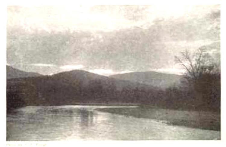
At the western end of our intervale, and lying entirely within it, there is a little hill which so resembles a sugar loaf, that it is named Sugar Hill. Were its summit bare granite, it would be Potash's duplicate on a smaller scale. Its sides slope off regularly and gently in all directions. In altitude it is 1,845 feet. On Sugar Hill huge boulders are strewn in every direction. Frank Bolles claims that this must have been either an island in the great lake which once existed in the Passaconaway Intervale, or the western shore of its waters. This hill is neither thickly covered with rich loam, as is the valley, nor does it show any signs of having been submerged.42 One of our favorite tramps is up the Swift River Trail. This may serve as an arbitrary dividing-line between our northern and western sky-lines. I can do no better than to give in substance a description of this old Indian path which was written by Prof. James Sturgis Pray:―The Swift River Trail follows, from the westerly end of the Albany Intervale, the Sabbaday Falls Path for perhaps a mile, or a mile and a half, from the Passaconaway House. Thence it runs alongside the south bank of the Swift, "sometimes skirting the very edge of its high bank, commanding beautiful vistas up and down stream, at other times out of sight (rarely out of sound) of its running water," for a mile and a half to Pine Bend. On this part of the trail we pass some noble stretches of smooth ledge. We press on until a logging road is gained which leads to Camp No. 6, perhaps a mile and a half. The divide between Kancamagus and Huntington is climbed and presently one reaches the headwaters of the East Branch of the Pemigewasset. Henry's old lumber railroad lies perhaps three miles west of the divide and leads to either North Woodstock or Lincoln. About the same distance from the divide one finds a trail leading south through the Mad River Notch, between Osceola and Kancamagus, to Waterville. "Everywhere it is through beautiful forest, from once entering just above Shackford's, till finally coming out upon the old logging road, and even this region is beautiful again, it having been logged so long ago.43 Among other interesting features of this trail there used to be a secluded cabin belonging to a prominent Conway physician. This was known as "Horne's Camp," and nearly everyone traveling the Swift River Trail enjoyed its hospitable shelter. The owner made it a point to keep it well supplied with non-perishable food and warm bedding. A few years ago this famous camp was destroyed by fire. In the days of its existence, if one wished for absolute solitude, unbroken only by visits from wood mice, bear, and other forest folk, this cabin offered such a haven as exists nowhere else. In my chapter on adventures, etc., I shall narrate some experiences which took place here. The Swift River and Swift River Trail lie at the base of Mount Kancamagus. In the chapter devoted to the chieftain of that name will be found a brief description of this mountain.
_____________ 1. Compare Osgood's: White Mts., 128.
|
 SUGAR HILL AND MOUNT HUNTINGTON